Tree mapping and inventory management
We offer a comprehensive platform for identifying and mapping individual tree and shrub populations. We also provide a historical to track the evolution of green cover and to measure carbon sequestration.
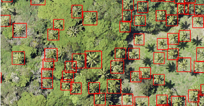
Tree identification and mapping
Our solution helps municipalities, national parks and project developers establish a detailed baseline of tree and shrub plantations in urban and desert areas.
- Automated tree specie detection using AI-based image recognition techniques
- Palm tree classification by cultivar
- Precise GPS geotagging of individual trees to create a digital twin of your plantation
- Digital Surface Model (DSM) with sub meter crown delineation and GIS ready shapefiles (GeoJSON/KML )
With over 10 years of
historical record, we can provide
tree cover comparisons from year
to year. We can document the
performance of landscaping
contractors in meeting their
contractual obligations.

ESG compliance reporting
We can provide audit grade data reports to substantiate environmental claims and sustainability commitments.
- Carbon sequestration metrics
- Biodiversity index
- Reforestation survival tracking
Tree management system
A detailed and accurate inventory of trees, shrubs and groundcover serves as a centralized collaboration tool for managing project teams. This is especially important in the early years of a project where tree mortality and growth rates are closely monitored. With our technical partners, we provide a customized solution with comprehensive reporting and flexible search options. Work orders can be scheduled through the system, and data access is provided through mobile devices.
- Asset ID number
- Location / GIS coordinates
- Tree species, genus, family
- Year planted or transplanted
- Age of tree
- Size of tree
- Canopy size
- Health rating
- Action required for O&M (and a record of past actions)
- Management notifications / escalations
- Contractor information
- Barcode/QR code integration
- Group Asset ID number (vegetation to be assigned in groups based on sites)
- Location / GIS coordinates
- Species, genus, family
- Year planted
- Health rating
- Action required for O&M (and a record of past actions)
- Notes / observations